The activity of Geosense focuses on the creation and development of products “key-in-hand” for cartography (maps), aerial photography, 3D modeling and maps for precision farming with the use of unmanned aerial vehicles (drones) to purchase very high resolution images.
The main advantages of this product are high precision, speed and cost over traditional methods.
Moreover these images may be taken at desired dates and with the resolution and quality which the customer wants to capture one cycle of processing, distribution of 2 to 3 days.
TOPOGRAPHIC SURVEYS / LAND SURVEYS
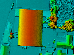
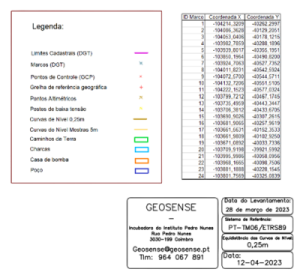
Geosense performs topographic surveys/land surveys using unmanned aerial vehicles (UAVs), also known as drones, following the highest standards and regulations regarding quality, safety, and efficiency.
UAVs fly autonomously or remotely, to capture aerial images of the terrain with digital cameras and GPS with RTK/PPK to improve accuracy. These images are processed using specialized algorithms to generate cartographic products such as orthophotos, digital surface models and contour lines. All surveys are delivered in digital format such as CAD (.DWG) , GIS (.SHP) and .PDF for immediate visualizations by non-experts.
Geosense team includes accredited technicians that follow the cartography standards and technical specifications published by the General Directorate of Territory (DGT) to comply with municipality requirements for topographic surveys.

OTHER SERVICES
 Aerophotography
 3D Models
 Agriculture Maps
 Aerial Inspections
CONTACT US
We are here to help answer your questions, our experts are on hand to advise on all aspects of our service.
Do not hesitate to contact us.